2023 Hurricane Season

Status
Not open for further replies.

MikeFisher

The Fisherman/Weather Mod
Feb 28, 2006
13,771
2,206
113
Punta Cana/DR
www.mikefisher.fun
Did you add 8 additional batteries to an existing battery bank?

Doing so is not recommended since the older battery bank will "age" the new batteries.
Yes, I did, I already had a bank of 8, now they are bank of 16.
Not a problem with aging, as my "old" ones are running with little use since only last October, it was a needed upgrade due some power consumption changes I did lately.
Generally you are absolutely right, if the old batteries are already worn out, you should buy all batteries new to connect and better sell the old ones for a reasonable price, but that was luckily not necessary here, yet.
 
  • Like
Reactions: JD Jones

windeguy

Platinum
Jul 10, 2004
42,465
6,136
113
Yes, I did, I already had a bank of 8, now they are bank of 16.
Not a problem with aging, as my "old" ones are running with little use since only last October, it was a needed upgrade due some power consumption changes I did lately.
Generally you are absolutely right, if the old batteries are already worn out, you should buy all batteries new to connect and better sell the old ones for a reasonable price, but that was luckily not necessary here, yet.
Time will tell.
 

Drperson

Well-known member
Sep 19, 2008
1,100
310
83
Yes, it states what I explained.
In shorter words:
Our Tropical Highway is this season already ready with high power fuels for storms, it is right Now stronger than it usually would be during our hurricane peak times in summer(august/september), due very above normal/average Sea Surface Temperatures and Ocean Heat Content, as the weak Trade Winds do not stirr up enough deeper ocean waters to cool down the surface.
But, at the same time we get higher wind shear forces, which are a strong bothering element for storm development.
The resulting weak Trade Winds allow the ocean waters to be very hot on the surface and do not bring as much Saharan Dust as usual,
but they also bring less Moisture, whjch is also a missing significant factor to fuel/grow/develop big storms.
An other result of all that is a Weak Atlantic High. To explain this very important thing for storm affects on our Island:
The Atlantic High is a high pressure ridge located North of our Highway.
Surface low pressure systems(our Storms) do avoid such regions like the Devil avoids holy water, lol.
That means that form, size and strength of that Atlantic High is Always the Mayor Factor deciding in which direction a storm out of our East/coming over our Highway, will go.
Naturally, a storm would wander heading NW.
But with a usually strong Atlantic High North of a storm's area, it is forced to wander more W than N, even straight W'wards,
so that's then the storms coming straight into the caribbean Sea, threatening the Northern Islands belt, PR, Hispañola etc.
A weak Atlantic High means that storms get a more or full NW heading, which is very good for us here on the Island,
as due that it is more likely that the storms approaching from Our East will miss us and pass on our NE towards the Bahamas or even earlier out up to the hurricane graveyard mid atlantic.
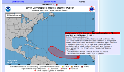
A good example is the Actual Disturbance/Invest, hitting Atlantic waters as we speak off the West African Coast.
IF it forms, it will wander around 7 " North, that would be a perfect positioning for a Westward Runner to enter the caribbean sea or approach PR/Hispañola from the SE in a week from now, under normal strong Atlantic High Conditions.
With the High Ridge weak, it will stay down around 7-9 degrees N only until it reaches half way of the highway and then turn NW to miss the Caribbean on our NE.
To have such starting run and development today, June 15th!!!, I guess that would be a long time record margin to get a big boy before end June on the doorstep.
No worries, it will Not happen.
What will happen, IF it stays up long enough, is my directional description only.
As for powers/development:
the hot waters may allow to stay up as a area of disturbed weather for several days,
BUT Windshear over all of our Highway is violently high, out there there is no moisture to collect and fuel/build a big storm,
so there is nothing to worry about out there.
It is a very early season interesting heavy weather area, which gives us the opportunity to learn about this first half of the season Strom behaviors, specially in case of their Heading/Directions, so we start to learn what may happen later this season, when conditions allow that a disturbed weather area collects moisture and forms into a storm.
Maybe it stays on long enough to show us the directional Path all the way from Africa towards the Lesser Antilles,
but most likely it will be gone long before reaching that far W'ward.
View attachment 7862
I could not have said it better myself
: )
 

MikeFisher

The Fisherman/Weather Mod
Feb 28, 2006
13,771
2,206
113
Punta Cana/DR
www.mikefisher.fun
Just to keep our topic up to date, but nothing new out there.
Invest92 is a Low centered somewhere 10th/12th"N wandering westward.
Waters are hot all over our tropical highway, Saharan Airlayer is thin.
The former super high windshear is declining day by day, so to form a TD is possible when the Low reaches around mid highway,
that position should be reached around Tuesday/Wednesday on actual forward speed.
So far nothing to fear, as Tracking patterns stay still all the same, the more West it goes the more NWwards it turns,
looks like a clear miss of any Caribbean Islands NE of the Virgins, no matter it forms a storm or not.
 

Attachments

  • Screenshot 2023-06-17 133618.png
    Screenshot 2023-06-17 133618.png
    416.2 KB · Views: 141

MikeFisher

The Fisherman/Weather Mod
Feb 28, 2006
13,771
2,206
113
Punta Cana/DR
www.mikefisher.fun
as long as the Atlantic High stays weak, the activity will be heading NW, that means for most that comes out of our East to be passing out on our NE.
The longer that lasts the less worries for us, but this season is very young and our hot drought conditions will anyways be headaches enough this year, it will be tough without any storms chiming in.
 

MikeFisher

The Fisherman/Weather Mod
Feb 28, 2006
13,771
2,206
113
Punta Cana/DR
www.mikefisher.fun
Windshear opened the path for today and the Atlantic High keeps widening a 1020mbar high pressure line,
while the waters are overly hot(this will not change this season til the end) and Saharan dry air is thin/barely existing over the highway.
The Invest 92 shows bettering organization and even that the environment is mostly dry it already carries enough moisture with it to form a storm/TD under such favorable conditions.
Locations is today on 9"N, at the 10th it will start rotation movement, so by Wednesday we could have our first TD out there half way past the Highway already then.
Tracking can get messed up and get a new face then, as that formerly small and weak high pressure area did change and keeps transforming.
Due that it is not assured that the System will do the promised NW Move that early, which can bring it closer or even in In the Caribbean.
By Wednesday we shall see whats up for the next weekend.
Have a great sunday everyone
 
  • Like
Reactions: NanSanPedro

CristoRey

Welcome To Wonderland
Apr 1, 2014
11,858
8,127
113
I lost my home along with my neighborhood when the levies broke during Hurricane Katrina.
Hurricanes suck.
What follows is far worse.
My advice would be to heed the warnings should you ever find yourself in the path of one.
 

MikeFisher

The Fisherman/Weather Mod
Feb 28, 2006
13,771
2,206
113
Punta Cana/DR
www.mikefisher.fun
Shi.t,
I di not "sent" my post from last evening, now that I wanted to update, I saw that it was still in my draft.
So here we go with Today's situation.
This heavy weather area surprises right away, as I would not have expected this one to organize and grow that quick.
We have now TD3 out there on the Highway,
No high amount of bothering Saharan Air in the way,
Windshear with an open path to not bother development during today,
It is a Storm with a clearly defined Center and nicely placed power areas all around that center,
such is named a great base to form up a powerful storm within a short time frame/maybe a couple days only.
By the actual standing we can expect to see a Cat1 Hurricane(the power calculation can vary a lot) over the Central Lesser Antilles by later Thursday/early Friday.
By then it should already be a Hurricane Force since at least 24hrs prior to arriving there.
The Eastern Caribbean Sea shows today no bothering windshear and the whole Caribbean Sea Waters are perfectly Hot,
which all together makes for a high fueling potential for a storm to grow stronger and even quicker once over Caribbean Sea Waters.
So far there is no indicator for any conditions to bother the powers that we see growing up out there now.
As always, Tracking/Final Destination is this far out not to be set with certainty,
but the size and positioning and shape of the Atlantic High predicts clearly that this one will hit the Antilles right in the middle
and continue in the eastern caribbean sea with a more NWern turn. that turn should start around the time when it almost arrived or once it arrived at the Lesser Antilles, but completely depending on any changes of positioning and strength of the Atlantic High(a permanently occuring process).
It is way too early/far away to run anybody nuts, but a Hurricane on our S or even approaching from our SE our Island is at this moment within the long range possibilities.
Screenshot 2023-06-19 124024.png

Screenshot 2023-06-19 124438.png
 

MikeFisher

The Fisherman/Weather Mod
Feb 28, 2006
13,771
2,206
113
Punta Cana/DR
www.mikefisher.fun
As this afternoon's update there is no more to say than that we have to watch this, which is named Tropical Storm Bret.
And the ones with a cistern in the make for stormy times, should finish cistern works Very sooon.
 
  • Like
Reactions: reilleyp

JD Jones

Moderator:North Coast,Santo Domingo,SW Coast,Covid
Jan 7, 2016
12,086
8,443
113
Not worried. My place is walled in and surrounded by trees.
 
Status
Not open for further replies.